skip to main |
skip to sidebar
Events of Tuesday, 29th November
Overnight we had headed away from the Antarctic Peninsula to intercept a unique island, Deception Island, which lies south of the main South Shetland Group. Early explorers considered the island ‘normal’. It was only later that a narrow passage (‘Neptune’s Bellows’, around 230m wide) was identified establishing that the island was, in fact, horse-shoe shaped, offering a protected anchorage around 9 km by 6 km within the horse-shoe. The misleading appearance of the island gave rise to the name ‘Deception Island’.
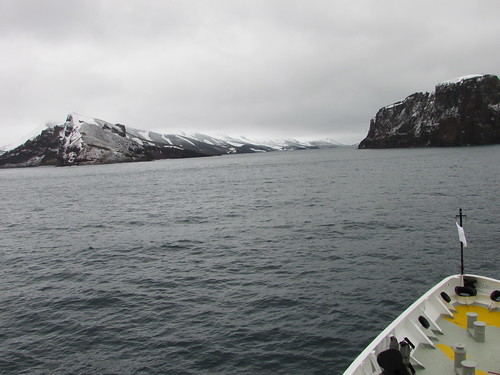
Deception Island: Approaching Neptune's Bellows.
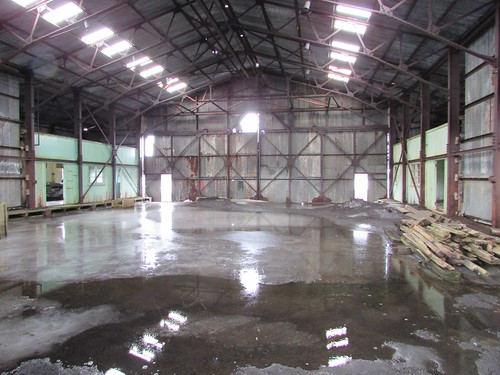
The whole island is an ‘active’ volcano, where an earlier eruption had caused the side of the cone to collapse, allowing the sea to flood the caldera, producing the present arrangement. The island provided a useful refuge to the early sealers and whalers then, in 1906, a base was constructed in Whalers’ Bay, which supported 13 whaling factory ships by 1914. The role of the onshore plant was to boil whale carcasses to extract whale oil but, following the price collapse during the Great Depression, the base was abandoned in 1931, to be later used by the British for a time as a research station.
Whalers’ Bay
We were encouraged to be on deck for around 8.00 a.m. to observe the passage through Neptune’s Bellows. Starting at 9.00 a.m., a wet landing by Zodiac was offered, allowing walking around the extensive, flat area of black 'sand' leading back from the sea. The buildings and equipment in Whalers’ Bay are in derelict condition and a decision has been made not to attempt restoration.

Deception Island: Derelict buildings and equipment in Whalers’ Bay.
I spent my time walking from the landing point to the abandoned aircraft hanger and back, making a photographic survey of the buildings, equipment and wildlife.
Deception Island: The abandoned aircraft hanger, Whalers' Bay.
I didn’t take the guided walk to a viewpoint called Neptune’s Window as I’d done that on my earlier visit to Deception Island in 2008 (described here).
Near the Zodiac landing, steam could be seen rising and, in places, the water and black 'sand' were pleasantly warm, attesting to the ‘active’ nature of the volcanic site (the last eruption was in 1970). However, I declined to take the ‘Polar Plunge’ by swimming in the (hopefully) warm water as I’d done that in 2008, although a number of my fellow guests did accept the challenge.
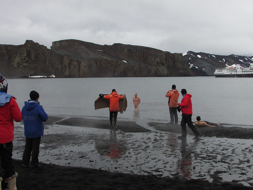
Deception Island: One guest makes use of his hat when emerging from a 'skinny dip' whilst another takes the 'warm sand treatment'.
After a very enjoyable shore visit, it was back to the ship by Zodiac, in time for lunch in the restaurant. Whilst we enjoyed lunch, the ship re-positioned to Telefon Bay, also within the caldera of Deception Island where we had a final opportunity to go ashore.
Telefon Bay
It was quite cold when we made our landing on a windswept beach of black ‘sand’. A 1 km walk was offered to inspect the crater formed during the 1970 eruption. Most of the route was covered in soft snow which made walking very tiring. I was on the point of turning back when Steffan from the Expedition Team pointed out how close the crater rim was so, after a breather, I persevered and was rewarded with an impressive, if bleak, sight.
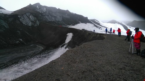
Deception Island - View of the crater, Telefon Bay.
Quite a few guests continued on a further 2 km hike which they concluded with a slide down a snow-covered hillside on their way back to the landing point. I decide to retrace my outwards route back to the Zodiac, in the company of quite a few guests.

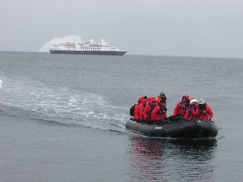
Deception Island - View of our ship, Telefon Bay.
The wet landing at Telefon Bay was the last trip ashore before we left the South Shetland Islands to cross the Drake Passage to our final destination, Ushuaia in Argentina. However, the weather forecast for the area was not promising, so the Captain decided to move the ship outside the caldera of Deception Island and anchor overnight, hopefully allowing the unfavourable weather system to pass before we attempted our passage.
In the evening I attended the Captain's Farewell Cocktail Party in the theatre followed by the Captain's Farewell Dinner in the restaurant.
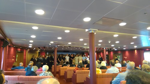
'Silver Explorer': Most of the crew, housekeeping and catering staff on stage in the theatre at the Captain's Farewell Cocktail Party held on Tuesday evening.
Related Posts
Next post describing this trip: Into the South Atlantic.
All posts describing this trip: Chilean Fjords.
Just posts on the Antarctic segment: Antarctic Peninsula.
My pictures
Where necessary, clicking on an image above will display an 'uncropped' view or, alternately, my pictures from this (and earlier) trips may be selected, viewed or downloaded, in various sizes, from the albums listed:-
Deception Island - 2016.
'Silver Explorer'.
All my pictures taken in Antarctica on both this visit and my earlier visit in 2008 are in the collection here.
[Links to pictures added 6-Feb-2017: Pictures added 8-Feb-2017]
Events of Monday, 28th November
Brown Bluff
Brown Bluff is located on the Antarctic Peninsula, facing the Antarctic Sound. A rust-coloured, steep-sided, flat-topped mountain towers above a shingle beach which is home to Gentoo and Adelie penguin rookeries.
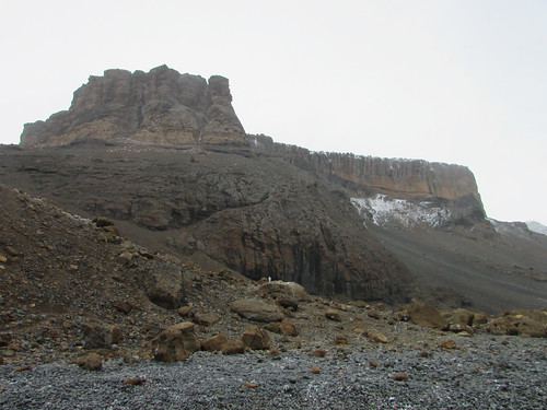
Brown Bluff
The Zodiac ride led us through numerous large pieces of ice to a wet landing on the beach. The wind was quite sharp and it was snowing, so I was well wrapped-up.
Brown Bluff: A Zodiac lands another group of guests.
Although some of the penguins were nesting around the large rocks at the foot of the cliff, most were congregated near the shore so we were asked to take a path higher up the beach. We passed colonies of both Gentoo (readily recognised by their white ‘ear muffs’) and Adelie (no head marking but with piercing eyes) commencing nesting.
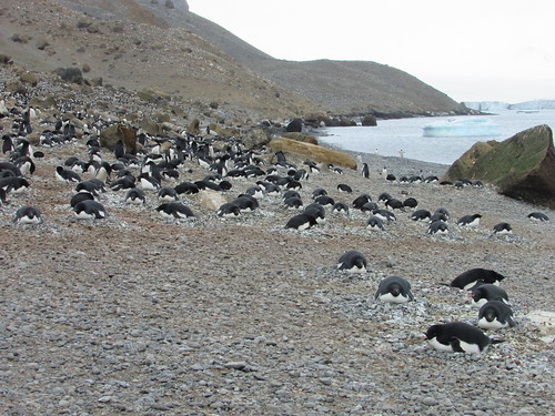
Brown Bluff: Adelie penguins nesting on the beach.
Both species on the beach were either standing, perambulating or, in a few cases, lying on their front. The Adelie has a very urgent way of walking (“I’m late, I’m late, for a very important date”) and they seem very sheep-like, walking one after another, single-file. One of my new friends suggested their behaviour was “lemming-like”.

Brown Bluff: A group of Adelie penguins march, single-file, across the shingle.
Puzzling is the way there can be a sudden change of plan, where the direction of travel is suddenly reversed. At times, a column of Adelies would end at the water’s edge and, one after another would dive in, apparently in pursuit of fish. But, on at least one occasion, we saw a version of the ‘change of plan’ behaviour where, almost as soon as the penguins had entered the water, they were hastening out again.
We had been offered a guided walk by Hans Peter to the moraine area of the adjacent glacier. I started on this walk which started by climbing a rather steep diagonal pitch up a hill from the beach over loose ‘scree’. There were good views from the top of this climb.

Brown Bluff: View from the top of the 'scree' showing the beach and numerous large pieces of ice.
Looking ahead, as the path crossed the moraine and continued up the ice at the edge of the glacier, I decided that it would be more prudent to return to the beach, particularly as the snow flakes were getting larger.
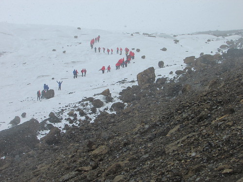
Brown Bluff: Guests crossing the moraine and continuing up the edge of the glacier.
So, having agreed my return with the Expedition Team, I very cautiously made my way back over the loose rock to the Zodiac Landing point. Back on the beach and finding partial shelter behind large rocks, I was happy to remain on the beach taking in the scene for some time before joining other returning passengers on the ‘Zodiac Shuttle’ service back to the ship. Once again, the morning’s activities had given me a good appetite for lunch. Whilst we enjoyed our meal, the ship moved along the coast to Hope Bay, where Argentina’s Esperanza Station is located.
Esperanza Station
Esperanza Station is a civilian settlement and research station built in 1953. In winter, there are 55 inhabitants, including a number of children.
At the kind invitation of the Station Commander, we made a wet Zodiac landing on a pebble slipway adjacent to a small jetty.
Esperanza Station: Guests coming ashore. The cemetery is visible in the background.
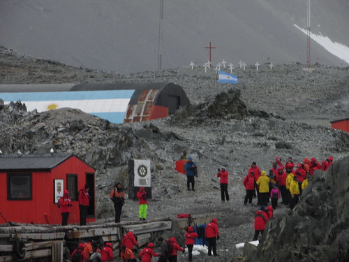
We were welcomed by the Assistant Station Commander and divided into two groups for a conducted tour around some of the station’s 43 buildings. Although some areas were roped off and reserved for the penguins on the island, the penguins, used to the presence of humans, wander unconcernedly across the whole Station.

Esperanza Station: A Gentoo penguin studies a large, abandoned satellite antenna in a 'Penguins Only' area.
We viewed the remains of the stone hut in which Andersson, Duse and Grunden were forced to over-winter in 1903 after the sinking of the 'Antarctic'. There's more information about this expedition here.

Esperanza Station: The remains of the stone hut in which Andersson, Duse and Grunden over-wintered in 1903.
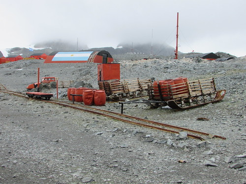
Some large artefacts from the early days of the Station, such as a ‘Snowcat’, sledge and a section of railway track have been preserved outside.
Esperanza Station: Large artefacts preserved outside.
Smaller objects were indoors in a nicely laid out museum building, including an incubator for human infants as used in the early period when there were at least eight births at the Station. Outside the museum, a series of cast brass plates listed the residents of the Station year by year.
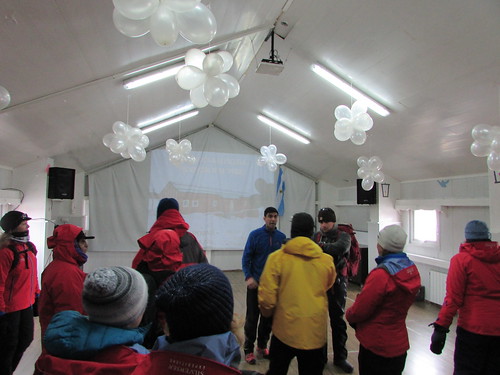
We were invited into the school building (not in use when we visited although I saw some young children by the jetty). The well-equipped building was kept heated so is also used for other functions. I was intrigued that the main room of the school was decorated with balloons but the schoolmaster explained that it had recently been used for his wedding to the lady teacher carried out by the Station Commander. The school provides pre-school, kindergarden, primary and (using distance learning) secondary education. The distance learning, of course, requires internet and a number of satellite dishes could be seen around the station providing voice, data and television services.
Esperanza Station: The Schoolmaster welcomes his visitors.
After we’d visited a small, nicely decorated Roman Catholic church, we were invited into the main meeting room provided with table tennis and pool tables, a seating area and bar. Trestle tables had been set along one wall with light refreshments for the visitors. Tables near the opposite wall were selling souvenirs relating to the Station.

The visitors enjoy refreshments and purchase souvenirs.
Everybody was most friendly and I was quite sad when we made our way back to the Zodiac landing point after a fascinating visit.
Tabular Icebergs
The day's excitement was not over because our course leaving Esperanza would take us through 'Iceberg Alley' where we were able to see a number of icebergs, including an impressive Tabular Iceberg, a huge flat-topped mass of drifting ice, rising at least 50 metres above the sea.
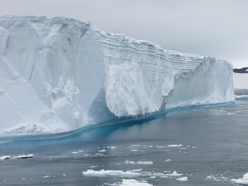
Tabular Iceberg.
For many of the guests, it was their first sighting of a Tabular Iceberg although, on an previous voyage, I'd seen a very large tabular iceberg or 'Mega Berg' which I described in the post South Georgia (day 4). The day ended with the ‘Recap and Briefing’ followed by a specially-themed buffet meal.
Related Posts
Next post describing this trip: Visiting Deception Island.
All posts describing this trip: Chilean Fjords.
Just posts on the Antarctic segment: Antarctic Peninsula.
My pictures
Where necessary, clicking on an image above will display an 'uncropped' view or, alternately, my pictures from this (and earlier) trips may be selected, viewed or downloaded, in various sizes, from the albums listed:-
Brown Bluff - 2016.
Esperanza Station, Hope Bay - 2016.
Tabular Icebergs.
All my pictures taken in Antarctica on both this visit and my earlier visit in 2008 are in the collection here.
[Links to pictures added, pictures added: 3-Feb-2017. Tabular icebergs added: 6-Feb-2017]


